Reninghelst New Military Cemetery
- Country Belgium
- Total identified casualties 798 Find these casualties
- Region West-Vlaanderen
- Identified casualties from First World War
- GPS Coordinates Latitude: 50.81703, Longitude: 2.75991
Please note
Due to road works in the area, access to this cemetery may be difficult.
PLEASE NOTE
The joints have been removed from the pavement. Grouting will not take place until the pavement stones are replaced during the winter.
Location information
Reninghelst New Military Cemetery is located 9.5 Kms south west of Ieper (formerly Ypres) town centre, in the village of Reningelst (formerly Reninghelst), on a road leading from the N308 Poperingseweg.
From Ieper town centre the Poperingseweg (N308), is reached via Elverdingsestraat then directly over two small roundabouts in the J. Capronstraat. The Poperingseweg is a continuation of the J. Capronstraat and begins after a prominent railway level crossing.
On reaching the main crossroads in the village of Vlamertinge take the left hand turning onto the Bellestraat. After crossing the N38 Ieper Poperinge road, the village of Reningelst lies 6 Kms beyond Vlamertinge. On reaching the village, turn right onto the Zevekotestraatand continue to the Reningelstplein where the churchyard is clearly visible. The Baljuwstraat leads from the Reningelstplein and the cemetery is 500 metres along this road on the left hand side.
Visiting information
ARRIVAL
The cemetery is signposted.
The cemetery is located within agricultural fields behind a residential area.
PARKING
The parking area for the cemetery is at the side of the main road in the residential area. There is space for multiple vehicles to park.
The ground is flat and firm with flat cobble paving, with a footpath running along the parking area.
The main entrance to the cemetery is approximately 140 metres from the main road. A grass footpath, approximately 900 mm wide leads between residential properties to agricultural land behind the residences. There are fences on either side of the footpath. The path can become muddy during inclement weather.
ACCESS LAYOUT AND MAIN ENTRANCE
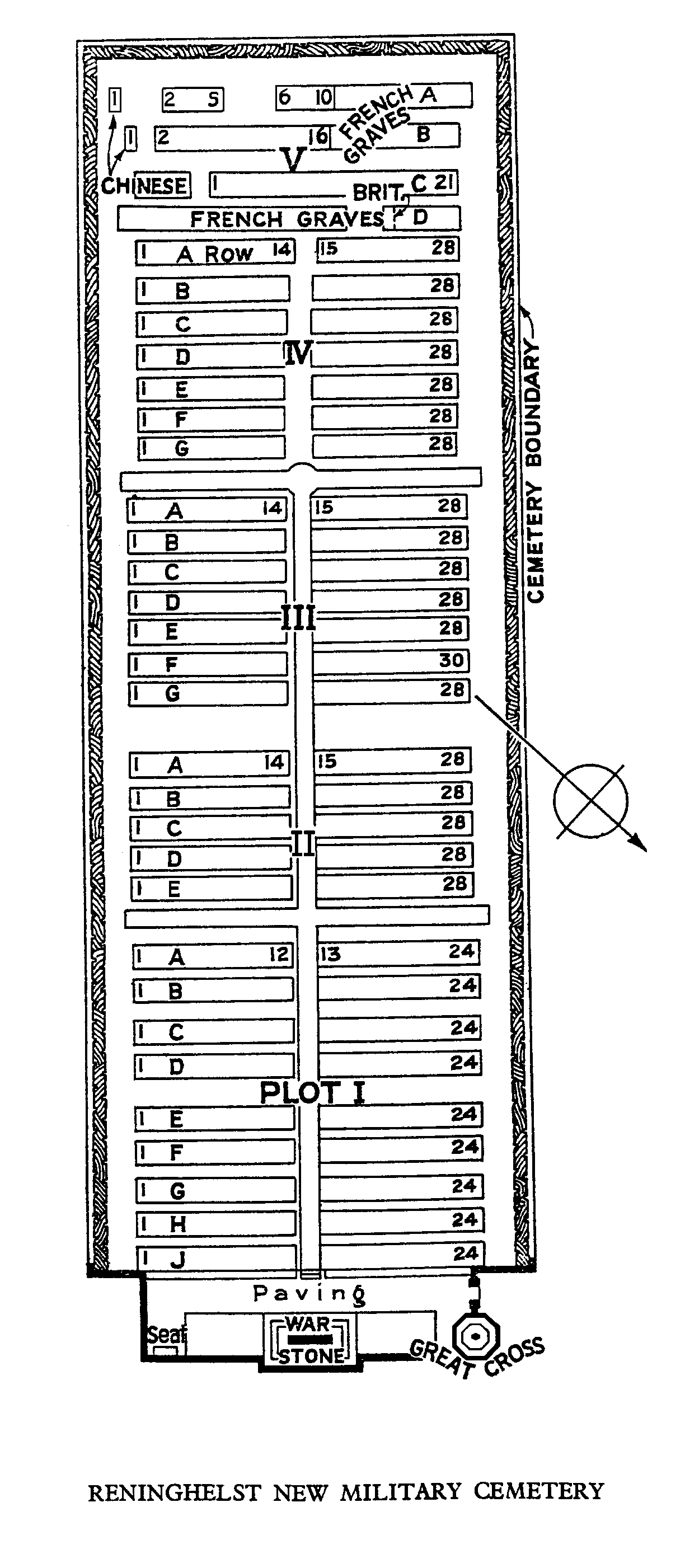
The cemetery is rectangular shaped and enclosed by a brick wall. Stone paving is located in front of the entrance. There is a small stone lip in the paving in front of the entrance, approximately 25mm high.
The main entrance has a mid-level (thigh height), black metal, 90-centimetre-wide gate with an up and down latch on the left-hand side. The gate opens into the cemetery. There is a 25 mm lip on the stone under the gate. This stone slopes upwards to the inside paving.
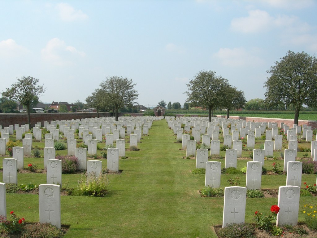
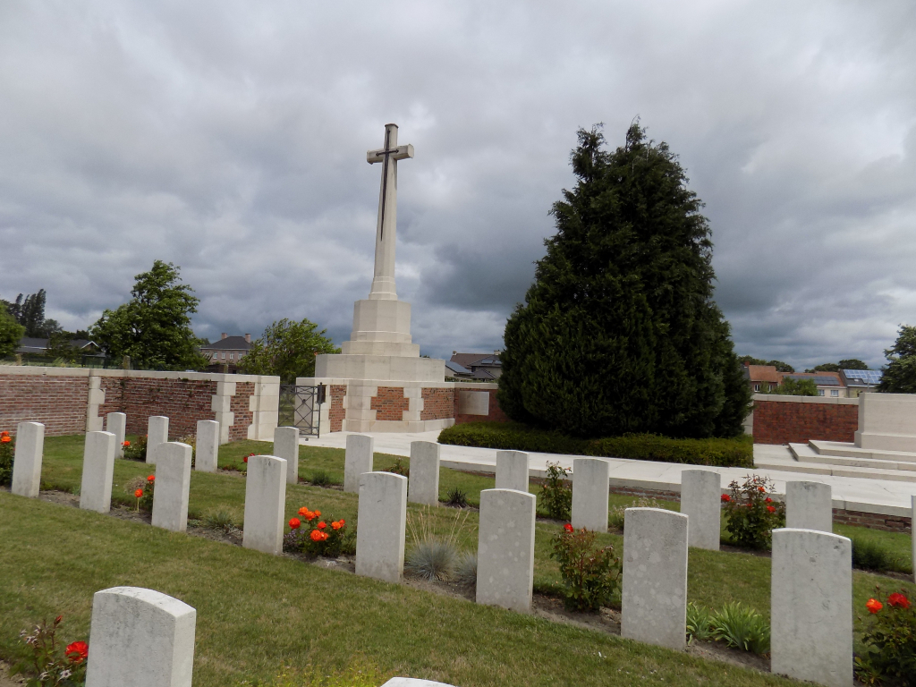
There is a stone platform running north to south along the eastern end of the cemetery. Immediately to the right of the entrance gate, the grass slopes down to the burial area, approximately 3 metres wide. The rest of the platform has a drop of 20 to 30 centimetres along the edge down to the burial area. The Cross of Sacrifice is built into the Entrance, and the Stone of Remembrance is mid-way along the platform.
Three steps lead down from the platform into the burial area in front of the Stone of Remembrance.
The Register Box is mounted into the wall inside the cemetery, just inside main gate on the left-hand side, next to the Cross of Sacrifice.
There is a brick and stone shelter building with an internal stone bench seating area at the back of the cemetery in line with the Stone of Remembrance. There is a small step up from the grass to the interior of the shelter building.
There is a brick and stone bench built into the wall on the north side of the cemetery, midway between the Stone of Remembrance and the shelter building.
All internal paths are grass, the ground is firm and flat.
ALTERNATIVE ACCESS
There is no alternative access into the cemetery.
ADDITIONAL INFORMATION
The cemetery is permanently open.
History information
The village of Reninghelst (now Reningelst) was occupied by Commonwealth forces from the late autumn of 1914 to the end of the war and was sufficiently far from the front line to provide a suitable station for field ambulances. The earliest burials took place in the Churchyard, but in November 1915, the New Military Cemetery was opened. It remained in use until September 1918.
There are now 798 Commonwealth burials of the First World War in the cemetery.
The cemetery was designed by Sir Reginald Blomfield.