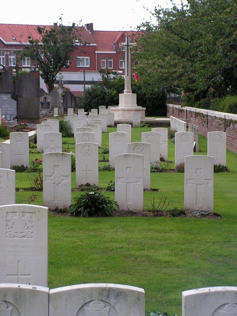
Nieuwkerke (Neuve-Eglise) Churchyard
- Country Belgium
- Total identified casualties 106 Find these casualties
- Region West-Vlaanderen
- Identified casualties from First & Second World War
- GPS Coordinates Latitude: 50.74562, Longitude: 2.8257
Location information
Nieuwkerke (Neuve-Eglise)Churchyard is located 12 Kms south of Ieper town centre, on a road leading from the Kemmelseweg (N331) which connects Ieper to Kemmel and onto Nieuwkerke.
From Ieper town centre the Kemmelseweg is reached via the Rijselsestraat, through the Lille Gate (Rijselpoort) and straight on towards Armentieres (N336). 900 metres after the crossroads is the right hand turning onto the Kemmelseweg (made prominent by a railway level crossing).
After passing the village of Kemmel the N331 continues for 4 Kms towards Nieuwkerke. On reaching Nieuwkerke turn right into Nieuwkerkestraat (direction of Armentiers). The churchyard is located 80 metres along the Nieuwkerkestraat on the left hand side of the road.
Visiting information
The CWGC (Commonwealth War Graves Commission) plot is a long rectangular strip of graves along the edge of the civilian plot within the Nieuwkerke Church (Neuve-Eglise) churchyard.
ARRIVAL
The cemetery is signposted.
PARKING
There are spaces for multiple vehicles (over 50) in a carpark opposite to the church.
Additional parking is available up the side and towards the rear of the church, where there is space for up to 10 vehicles.
There is a pedestrian crossing from the car park to the church.
There is an accessible parking space indicated by signs at the far-right corner of the car park.
The ground is flat and firm with a paved brick and tarmac surface.
ACCESS LAYOUT AND MAIN ENTRANCE
From the pedestrian crossing, opposite the car park, the CWGC plot is to the left-hand side of the church approximately 80 metres from the main entrance.
The brick path, approximately 35 metres long, leading from the pedestrian crossing towards the CWGC plot has 2 timber bollards at the end with a 76-centimetre access gap between them. It is possible to bypass the bollards. The brick path ends at the bottom left corner of the church. A grass pathway leads from there between rows of graves, a distance of 40 metres to the entrance of the CWGC plot.
The plot is surrounded by a low-level brick and stone wall. The stone coping is level with the surrounding cemetery, with the plot approximately 400 mm lower. Along the rear of the plot is a 1.2 metre high brick wall
The Cross of Sacrifice is on a raised brick and stone platform in the middle of the CWGC plot, level with the civil cemetery. The top of the platform is 400 mm higher than the plot and drops off to the grass below.
There are 3 stone steps on either side of the platform, in front of the Cross of Sacrifice leading down into the plot.
The Register Box is built into the churchyard wall to the right of the Cross of Sacrifice.
There is no seating in the CWGC section.
All internal paths are grass and the ground is flat and firm.
ALTERNATIVE ACCESS
There is no alternative entrance into the cemetery.
ADDITIONAL INFORMATION
The cemetery is permanently open.
History information
Nieuwkerke (also known as Neuve-Eglise) was captured by the Germans on from 14 April 1918, after a stubborn defence by the 49th (West Riding) and 33rd Division, and remained in their hands until it was retaken by the 36th (Ulster) Division on 2 September. The churchyard was used by field ambulances and fighting units at intervals during the war, particularly, in the early days, by the Cavalry and the 5th Division.
During the Second World War, the British Expeditionary Force was involved in the later stages of the defence of Belgium following the German invasion in May 1940, and suffered many casualties in covering the withdrawal to Dunkirk.
Nieuwkerke Churchyard contains 92 Commonwealth burials of the First World War and ten from the Second World War. There are also four war graves of other nationalities within the churchyard.


