10 June 2024
Visiting the beaches of Normandy – WW2 guide
Thinking of visiting the Normandy D-Day beaches? Here’s a handy guide on everything you need to know.
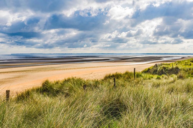
Normandy D-Day beaches to visit
As some of the most historic Second World War locations in the world, why not make a trip to see D-Day's landing beaches?
The five Normandy landing beaches are places steeped in history and legacy. Those who first stepped ashore on June 6 1944, did so at the forefront of the Allied invasion of Europe.
Their courage and sacrifice saw the Allies win one of the most important victories of the war. Just under a year after the Normandy landings, the Second World War in Europe was over.
Is it any wonder, then, that the beaches of Normandy are some of the most popular tourist destinations in France?
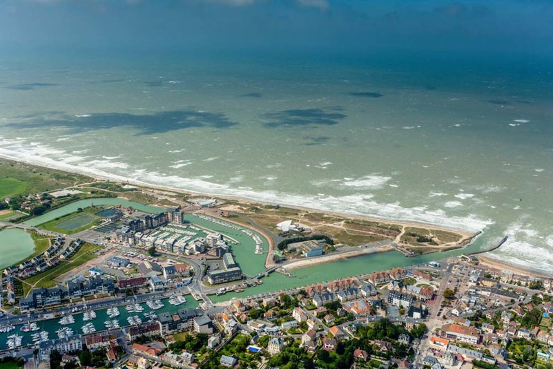
Gold Beach
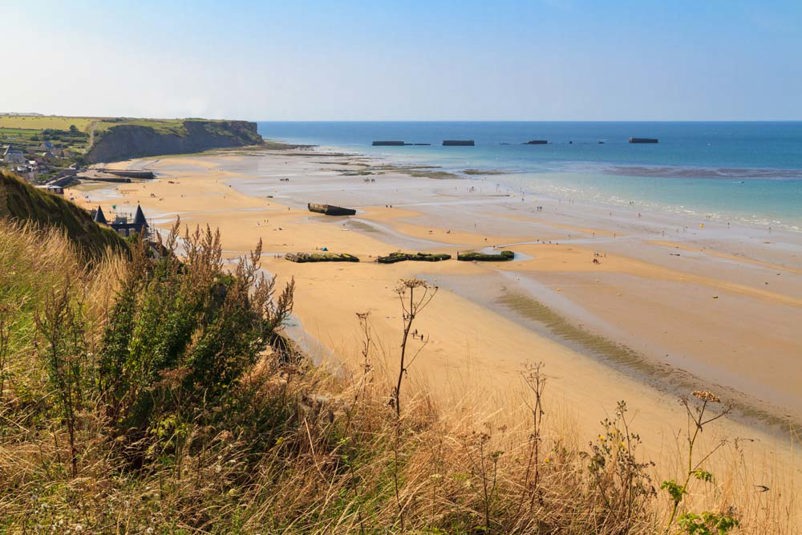
Where is Gold Beach?
Gold Beach was one of three Normandy landing beaches assigned to the Commonwealth forces on D-Day.
The landing zone stretched 8 kilometres from Port-en-Bessin in the west to La Rivière, Ver-sur-Mer in the East. The seaside resort of Arromanches lay in the west of the landing zone. Deeper inland from Gold sat the historic town of Bayeux.
History of Gold Beach
Wehrmacht forces occupying Gold Beach were tucked away in houses along the coast, particularly at La Rivière and Le Hamel. The landing beach was also in range of a gun battery located a kilometre inland, directed from a clifftop observation post at Longues-sur-Mer.
Gold comprised four sectors, running west to east: How, Item, Jig, and King. It was to be assaulted by the 50th (Northumbria) Division.
The 50th Division’s objectives were to capture Arromanches, cut the Caen-Bayeux Highway, and link up with the Canadians from Juno Beach in the east and the Americans from Omaha to the west.
Landing craft from the 50th Division hit Gold Beach at 7:25 am on the morning of D-Day. German defences had been softened by RAF and Royal Navy bombardment before the assault.
The infantry was supported by tanks and specialist Armoured Fighting Vehicles Royal Engineers (AVREs) to help clear beach obstacles and defences.
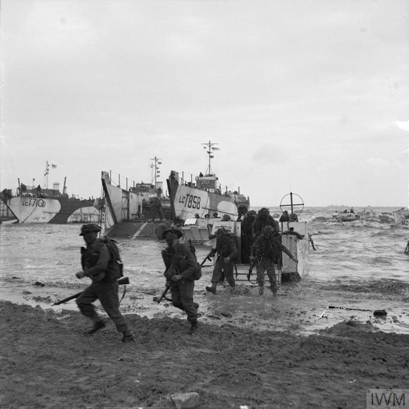
Image: 47 Commando comes ashore on Gold Beach, 6 June 1944 (© IWM)
At the same time as the main infantry assault, the special forces of 47 Commando came ashore too. Their target was to capture the small harbour at Port-en-Bassin at Gold Beach’s western edge.
No German tanks were present on Gold Beach. Infantry resistance was also minimal compared with other D-Day landing beaches. The Royal Navy and Air Force bombardments had effectively softened up defences.
German forces at La Rivière had been subdued by 10.00 am. By mid-afternoon, Le Hamel had been captured. 47 Commando pushed towards its objective at Port-en-Bessin but was unable to take the small port on D-Day itself.
One of the supporting Royal Navy vessels, HMS Ajax, disabled the Longues-sur-Mer battery after a furious long-range duel.
By the evening of D-Day, the 50th Division had landed 25,000 men on Gold Beach. The British pushed 50 kilometres inland. They also linked with the Canadians advancing from Juno Beach, but they failed to cut the Caen-Bayeux highway.
The forces at Gold made a good start, securing an important beachhead for 400 casualties.

Bayeux War Cemetery
Bayeux War Cemetery, started in 1952, has become one of the focal points for the commemoration of the Normandy campaign’s Commonwealth war dead.
Over 4,500 war graves can be found in Bayeux War Cemetery. D-Day war graves total around 500 of the Commonwealth burials here.
Within Bayeux War Cemetery stands the Bayeux Memorial, commemorating fallen officers and enlisted men with no known war grave. 1,800 servicemen are commemorated by name on the memorial.

Ryes War Cemetery
Ryes War Cemetery lies close to Arromanches.
The first burials at Ryes were made just two days after the landings on Gold Beach.
Today, it contains around 650 Commonwealth war graves, roughly a sixth of which were casualties killed in Normandy on D-Day itself. Interestingly, there are also around 330 German graves at Ryes War Cemetery.
Getting to Gold Beach
Gold Beach is accessible via public transport using Normandy’s transport network or by road.
For travellers from the UK, the fastest direct route to Normandy D-Day beaches is by ferry from Portsmouth.
The vessel docks at Ouistreham, taking you directly into the heart of the D-Day battlefields and landing beaches.
From Ouistreham, Arromanches and Gold Beach is about a 40-minute drive. Depending on traffic, it takes but takes around four hours when driving from Calais. Reaching Arromanches and Gold Beach from Cherbourg takes roughly an hour and a half.
Sword Beach
Where is Sword Beach?
Sword Beach was the most easterly of the Commonwealth Normandy landing beaches on D-Day.
It lies on an 8-kilometre stretch of the Normandy coast between Lion-sur-Mer in the west and Ouistrehem in the east. It is around 15 kilometres away from Caen.
Sword Beach was and is very sandy, with the surrounding landscape turning into dunes. In 1944, it had only been lightly fortified with beach obstacles and emplacements, although German defences stretched inland away from the beach.
An artillery battery at Merville, 8 km to the east, overlooked the beach. A range of mortars, 88 mm guns and machine guns were also built inland.
History of Sword Beach
Sword Beach was divided into four sectors for the D-Day assault. From west to east, they ran Oboe, Peter, Queen, and Roger.
Assaulting Sword were the men of the British 3rd Division, made up of regiments including the Suffolks, South Lancashires, and East Yorkshire, to name a few.
Accompanying the main assault were special forces units from the 1st and 4th Special Service Brigades.
3rd Division’s D-Day objectives were to land and push up the beaches to pass through Ouistreham and, if possible, capture Caen, as the region’s major transport hub.
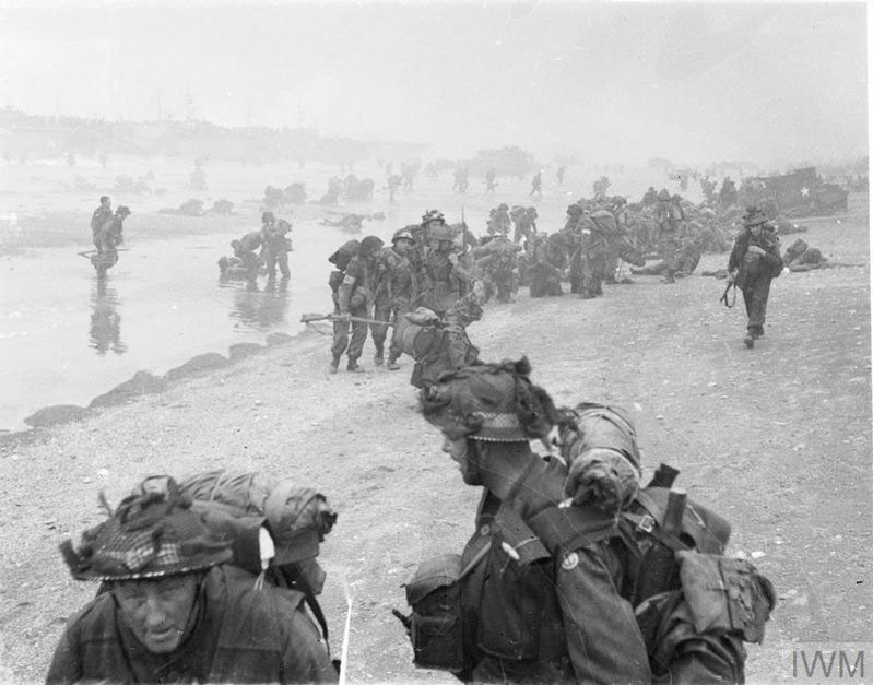
Image: 8.45 am Sword Beach, 6 June 1944 (© IWM)
The special forces were to push inland toward the Orne River and Caen Canal Bridges and link up with Airborne paratroopers and glider troops already in Normandy.
Seaborne forces’ landing craft hit Sword Beach at around 7.25 am. Fighting on the beach was relatively light. Within 35 minutes, Sword had been cleared, and combat moved inland.
In the early afternoon, the Commandos had managed to link up with the men of 6th Airborne.
6th Airborne had been in Normandy for hours already, dropping in behind enemy lines around midnight. It was their job to defend the Orne and Caen bridges to provide exit routes for the forces assaulting Sword Beach. Other units were assigned to knock out the Merville battery.
Both airborne objectives had been achieved by the time the amphibious assault began, making it easier for the regular army units to come ashore.
By the end of June 6th, the British had landed some 29,000 men on Sword Beach. Taking the beach and subsequent fighting cost the British around 630 casualties.
Caen remained out of British hands until the end of July 1944.

Hermanville War Cemetery
Hermanville War Cemetery contains many D-Day war graves, representing roughly a quarter of the 1,000 burials in the cemetery.
Hermanville is a small village that lies a short way behind Sword Beach.
It was occupied early on D-Day by men of the South Lancashire Regiment. Later that day, the Shropshire Light Infantry and tanks of the Staffordshire Yeomanry managed to capture Bieville-Beniville, around 4 km south of Hermanville’s south.

La Deliverande War Cemetery, Douvre
La Deliverande is only a short distance from Sword Beach, situated to the west of Hermanville.
The war cemetery was started not long after D-Day, with casualties from Sword Beach buried here, drawn from the beach’s Oboe and Peter sectors.
Over 1,020 personnel are buried at La Deliverande War Cemetery.
Getting to Sword Beach
Ouistreham is the quickest way to get to Sword Beach and the quickest way for UK visitors is via Portsmouth. The ferry from Portsmouth docks at Ouistreham.
Sword Beach is around three and a half hours by car from Calais and roughly the same by car from Paris.

Want more stories like this delivered directly to your inbox? Sign up for our newsletter for regular updates on the work of Commonwealth War Graves, blogs, event news, and more.
Sign UpJuno Beach
Where is Juno Beach?
Juno Beach lies between Gold Beach to the west and Sword Beach to the East.
The landing zone covered a 10-kilometre front, stretching along the small fishing port of Courseulles-sur-Mer.
Several small conurbations and villages lay behind the beach’s sandy dunes or dotted the seafront. German forces occupied and fortified them with gun emplacements, fighting positions, and casemates.
Hidden beneath the sea on the approach to Juno were several natural obstacles, including reefs and shoals, making the approach tricky to navigate.
History of Juno Beach
Juno Beach was the third assigned to Commonwealth armies for Operation Overlord. The Canadian Army, specifically the 3rd Canadian Division, was tasked with taking Juno and forging inland.
The Canadian D-Day objectives were to cut the Caen-Bayeux road, take the important Carpiquet Airfield near Caen, and then link up with the British troops making their way off Sword and Gold beaches.
Because of the natural hazards hidden beneath the waves, Allied planners had to launch the Canadians later than desired so their landing craft could clear the reef on the rising tide.
The Canadians landed on Juno at 07.55 am on the morning of June 6th 1944. Not only were they 10 minutes behind schedule, but they were also three hours behind the optimal tide height.
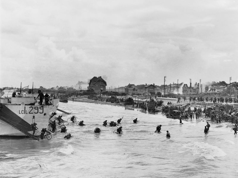
Image: Canadian soldiers leave their landing craft on Juno Beach (© IWM)
This gave the Canadians a problem. Juno was littered with now partially submerged beach obstacles. The Royal Canadian Engineers were unable to clear an unobstructed path to the beach, so landing craft pilots had to navigate by feel to get their men to shore.
Mines took a heavy toll on the Canadian landing craft. 30% of Juno landing craft were damaged or destroyed.
In contrast to the British at Sword and Gold, the Canadians had a much tougher time getting off the beach. At Juno, the German defences were more focused on overlooking the coastline, rather than firing out to sea.
As the Canadian infantry made its way up Juno Beach, it came into enemy killing zones, which reaped a terrible toll on the first wave. In the first hour of the assault, there was a 50/50 chance that each Canadian soldier would become a casualty.
The Canadians never wavered, however, and by mid-morning, they had captured the towns of Berniéres and Saint-Aubin, getting off the beach.
Progress into Normandy was good. Successive infantry waves supported by Canadian armour pushed on and, by the end of the day, the Canadians had made the most progress of any Allied army in Normandy.
But that progress was not without cost. Of the Commonwealth forces on D-Day, the Canadians took the highest casualties, suffering 1,200 casualties (340 killed) for 21,400 troops landed on Juno.

Beny-sur-Mer Canadian War Cemetery, Reivers
Beny-sur-Mer Canadian War Cemetery contains over 2,000 Second World War graves.
As the name suggests, most of the war graves in Beny-sur-Mer are Canadian.
Roughly 300 were killed on D-Day, either on Juno Beach or as the fighting turned inland.
How to get to Juno Beach
Most Canadians visiting Juno Beach will arrive in France via Charles de Gaulle Airport, around 25km north of Paris. From there, the quickest route would be a direct train to Caen or a three and hour drive from Paris.
Visitors from Britain are best to catch the ferry to Ouistreham as this will take you directly into the D-Day invasion area. Juno Beach is then a 25-minute drive, depending on traffic.
Reaching Juno Beach from Calais takes roughly 3 hours and 45 minutes by car. From Paris, it can take up to 3 and a quarter hours, depending on traffic.
Omaha Beach
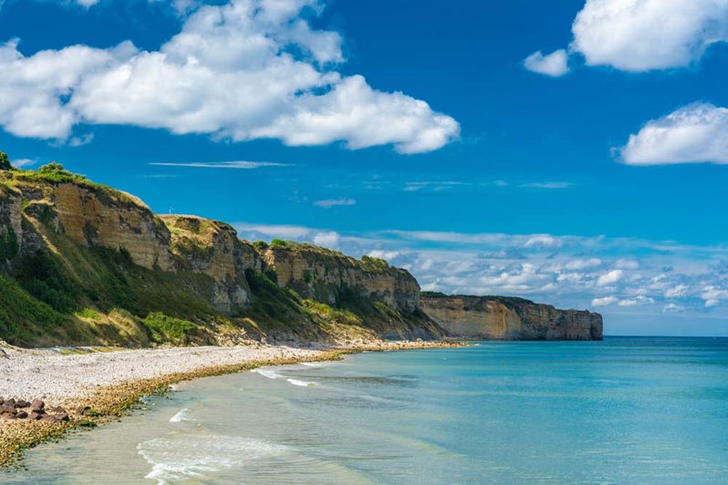
Where is Omaha Beach?
Omaha Beach was one of five landing beaches of the Normandy invasion. It was one of two assigned to the United States.
Omaha Beach stretched from Port-en-Bessin in the east to the mouth of the Vire River in the west, covering 10km.
The landing beach was overlooked by 30-metre-high cliffs. Some sections of the western beach were backed by a strong, 3-metre-high seawall as well.
German Field Marshal Erwin Rommel had ordered Omaha Beach to be fortified as part of his Atlantic Wall.
The waters were mined, and beach obstacles were laid. German machine gunners peeked out over the beach from vast concrete bunkers and redoubts. From the cliffs, a trench network wound its way inland.
Even today, numerous concrete strong points can be seen in and around Omaha, showing the area’s defensive lethality.
The history of Omaha Beach
Omaha was assaulted by the forces of the US 1st Infantry Division, aka the Big Red One.
1st Division’s objectives were to capture the villages of Vierville, Saint-Laurent, and Coleville. It was then to push onwards toward the Bayuex-Isigny Road and continue heading west towards Pointe du Hoc.
The attack began at 06.30 on the morning of June 6, 1944. Choppy waters and strong winds drove landing craft off course.
Omaha turned into a killing field. American troops sought cover behind beach obstacles or wrecked vehicles, pondering whether to make the risky run for the seawall.
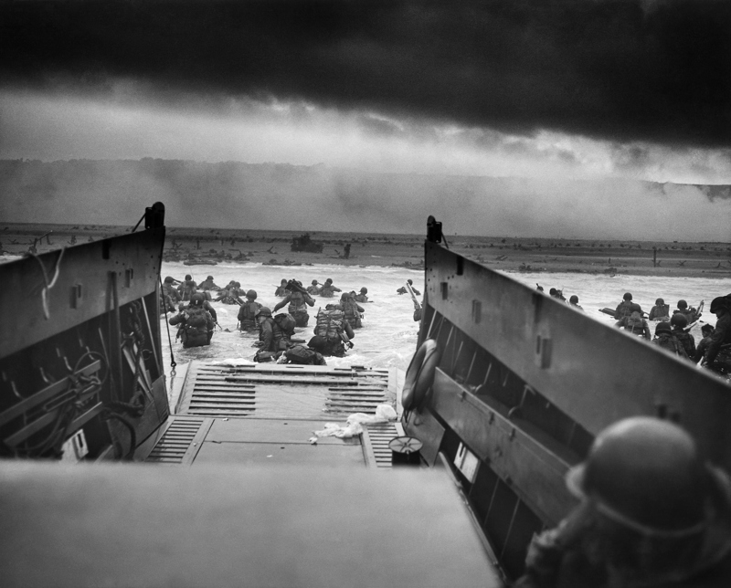
Image: "Into the Jaws of Death", Robert F. Sargent's famous photo of the US 1st Division's assault on Omaha Beach (public domain)
The carnage was so bad that by 08.30, all landings at Omaha had stopped. Men on the beach were left on their own. Slowly but surely, the US soldiers began to form groups and scale Omaha’s imposing cliffs.
To alleviate the pressure, US Navy destroyers sailed up to the beach and began bombarding German positions at point-blank range.
By midday, German fire noticeably decreased as defences were flanked and taken from the rear. Allied soldiers could now begin opening each of Omaha’s five beach exits one by one.
Elsewhere in the Omaha sector, the US Rangers were given the job of assaulting Pointe du Hoc.
Pointe Du Hoc is a rock escarpment jutting out into the English Channel, which gave fantastic views of the American landing beaches at Normandy at the time of D-Day. Atop were gun emplacements and casemates zeroed in on Utah Beach.
With rope ladders and grappling hooks, the Rangers scaled 100 sheer cliffs under heavy fire.
They managed to reach the top when, to their horror, they found empty casemates. Where were the big guns? Sweeping nearby, the Rangers thankfully found the German artillery, hidden in a sunken road, and disabled it.
By nightfall on D-Day, the US held ground around Vierville, Saint-Laurent and Colleville. The advance was far behind schedule, but the resistance had been incredibly tough at Omaha.
The US forces at Omaha had suffered 2,400 casualties but had managed to land 34,000 men.
How to get to Omaha Beach
Omaha Beach is around 40 minutes from Ouistreham, the disembarkation point of the Portsmouth-Caen Ferry. This would probably be the quickest way to reach Omaha Beach for UK visitors.
For those coming from Calais, the journey is roughly four hours by car.
American tourists paying a visit to the Normandy D-Day beaches are most likely to be arriving in France via Paris Charles de Gaulle Airport. By car, this will take between three and a half and four hours.
Utah Beach
Where is Utah Beach?
Utah Beach was the most westerly of the five Normandy D-Day landing beaches.
It lies at the base of the Cotentin Peninsula, at the top of which sits the great Atlantic port of Cherbourg.
Utah covered 5 kilometres, running northwest of the Carentan estuary along a ribbon of sandy, dune-covered beach.
Four causeways exited Utah Beach, leading to the important crossroads towns of Carentan and Sainte-Mére-Église.
The land behind Utah is flat, open, and low-lying. To limit enemy movement, the Germans had flooded these areas and could control the flood levels with locks.
The history of Utah Beach
Of the Normandy landing beaches assaulted by US forces, Utah was the least heavily defended.
The assault began at 06.30 am, led by the IS 4th Infantry Division.
Their goal was to capture the beach, take control of the coastal roads, link up with Airborne elements dropped earlier in the day, and get ready for a later attack on Cherbourg.
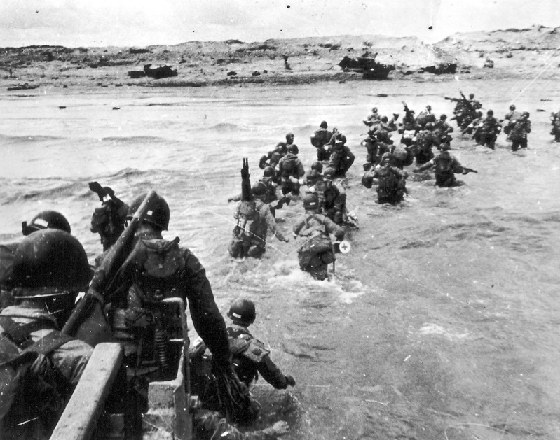
Image: US troops wade ashore on Utah Beach (public domain)
The Utah landings were met with confusion. Strong currents blew the landing craft off course while the beach was obscured by smoke from the preliminary Allied naval bombardment.
Three control craft, essential for guiding troop transports to the beach, were lost to mines.
Eventually, the Americans were able to land some 1,800 metres away from their designated area, leading commander Brigadier-General Theodore Roosevelt Jr. to declare, “We’ll start the war from here!”.
This turned into a happy accident. The Americans had landed at a lightly defended section and within three hours had captured three of Utah’s four beach exits. By noon, they had linked up with paratroopers of the 101st Airborne.
By the end of D-Day, 20,000 Allied troops and 1,700 vehicles had landed at Utah.
How to get to Utah Beach
The closest ferry stop near Utah is Cherbourg, which is about 45 minutes away by car.
American visitors to Normandy’s historic D-Day beaches are likely to arrive in France at Paris Charles de Gaulle Airport. Then it is around a four-hour car journey to Utah Beach.
If driving from Calais, the journey to Utah takes around four and a half hours.
Normandy landing beaches map
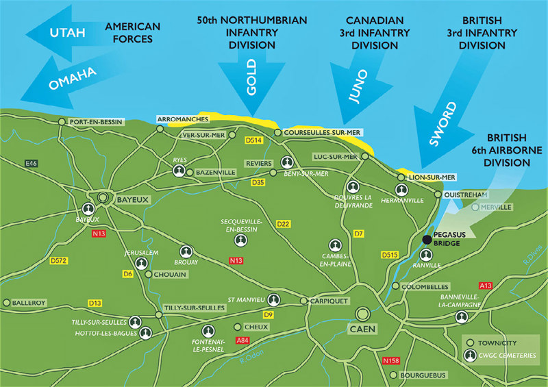
Image: Map of the Commonwealth Normandy landing beaches with CWGC cemeteries and memorials highlighted.
Normandy beach tours
Guided tours are available where battlefield guides take visitors to the beaches.
These extend from week-long package deals to coach and minibus trips to day excursions to Normandy’s varied remembrance sites.
Self-driving tours are a very popular way for history enthusiasts to experience the beaches of Normandy. Cycle tours are also very common, taking in the beaches and the bocage.
Normandy boasts a wide network of tour operators and battlefield guides, but at present, Commonwealth War Graves does not partner with any tour operators in the region.
Visiting Normandy landing beaches from the UK & France
Ferry or Eurotunnel are possibly the easiest ways to visit the Normandy landing beaches from the UK.
There are multiple ferry crossings with some sea routes landing in Ouistreham (Caen), Cherbourg and Le Havre, which are all within a reasonable driving distance from the beaches.
Calais is a short ferry crossing. The Eurotunnel crossing also ends in Calais. However, the drive to Normandy can take up to four hours, depending on which beach you are visiting.
Normandy is connected to the rest of France by its extensive motorway and railway network.
How long does it take to visit Normandy beaches of WW2?
The D-Day landing beaches stretch over 70 kilometres of the Normandy coastline. It may be difficult to fit all of them into just one trip.
There is a lot to see and learn at these locations and landmarks. Rushing through the sites may not be the best way to experience everything the beaches of Normandy have to offer.
Reports from tourists on sites such as TripAdvisor suggest two days should be enough to visit Normandy D-Day beaches.
What’s the best Normandy landing beach to visit?
That depends entirely on your particular area of interest or connections to the D-Day story.
For Canadians, for example, Juno Beach and the museum there will likely be the first port of call on a Normandy beaches trip.
UK tourists may prefer to visit Sword and Gold Beaches. For US tourists, their first interaction with Second World War history may have been through the stories of Utah and Omaha Beaches, so they may be more drawn to them.
Each beach is a location steeped in history. There are museums, old bunkers and gun emplacements, and artefacts of the Normandy landings at each.
In the case of the Commonwealth landing beaches, Commonwealth War Graves cemeteries and memorials are close by too, commemorating many of the men who were killed storming the beaches of Normandy.
What’s the best time to visit Normandy beaches?
Between April and October is considered by organisations such as Normandie Tourisme as the best time to visit the Normandy beaches.
Temperatures are generally mild through spring to autumn, averaging 15-28°C (55-85°F), so the weather should be pleasant.
The summer is when tourism will pick up, especially in June, when D-Day anniversary events will be taking place across the beaches and at locations tied to the invasion. Normandy is likely to be very busy at times like this, so take that into account when planning a trip to Normandy.
For cooler weather and fewer crowds, try visiting in April/May or September/August.
What’s the best way to visit Normandy beaches?
Again, this is dependent on your circumstances, itinerary and how you like to engage with historical sites. You may wish to book a guided tour or visit at your own pace. There is no definitive “best” way to visit Normandy beaches.
Where to stay when visiting Normandy beaches?
The beaches are lined with many small villages and seaside towns, as well as larger places like Arromanches and Ouistreham.
Each is full of hotels, guest houses, and bed and breakfasts offering accommodation.
According to Camping France, there are 36 campsites near the Normandy beaches.
Do I need a guide to visit Normandy beaches?
You do not need a guide to visit Normandy beaches.
Can you visit Normandy beaches without a tour?
Yes, Normandy’s D-Day beaches are easily accessible to the public without tour guides.
Are you allowed to go on a Normandy beach?
Yes, these are public beaches and open for everyone to enjoy.
At the height of tourist season, the beaches are covered in beachgoers enjoying their summer holidays with swimming and making sandcastles, intermingling poignantly with the reminders of the Atlantic Wall and D-Day landings all around them.
Other memorial sites to visit in Normandy
When it comes to Normandy WW2 memorial sites, you are spoiled for choice.
There are over 115 Commonwealth War Graves sites in the Calvados region of Normandy alone. They are reminders of the cost of D-Day and the Normandy Campaign.
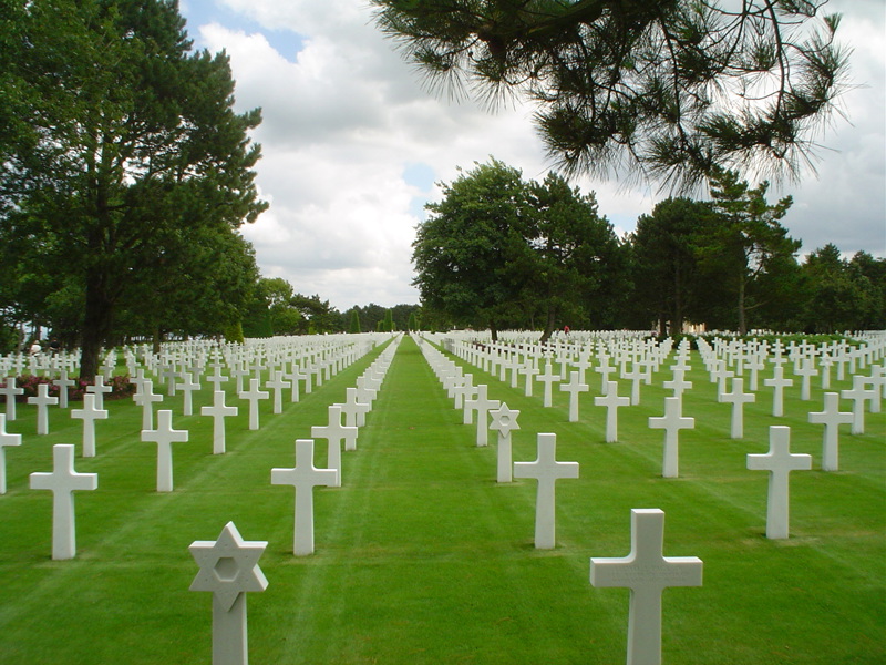
Image: The Normandy American Cemetery (Public domain)
American troops are commemorated at the Normandy American Cemetery. It holds over 9,000 Second World War burials. A further 1,500 are commemorated on the Normandy American Memorial.
German casualties are buried at La Cambe German War Cemetery. Once an American war cemetery, La Cambe has been a German site since 1948 and holds 21,000 burials.
GOT A STORY FROM D-Day and the Normandy Campaign? SHARE IT ON FOR EVERMORE
For Evermore: Stories of the Fallen is our online resource for sharing the memories of the Commonwealth’s war dead.
It’s open to the public to share their family histories and the tales of the service people commemorated by Commonwealth War Graves so that we may preserve their legacies beyond just a name on a headstone or a memorial
If you have a story to tell of a casualty we care for who fell in D-Day and the Battle for Normandy, we’d love to hear it! Head to For Evermore to upload and share it for all the world to see.
Visit For Evermore and explore personal stories of service and sacrifice
Author acknowledgements
Alec Malloy is a CWGC Digital Content Executive. He has worked at the Commonwealth War Graves Commission since February 2022. During that time, he has written extensively about the World Wars, including major battles, casualty stories, and the Commission's work commemorating 1.7 million war dead worldwide.